
How to Measure a Roof on Google Earth
Google Earth allows you to explore Earth’s surface in the most detailed manner possible. Thanks to its 3D representation, you can even use Google Maps to estimate the area of a roof. Whether you need an estimation for a new metal roof or for installing solar panels, using Google Earth to take measurements is a convenient option. But how accurate is it for measuring areas and perimeters of different surfaces? On which devices can you measure a surface or roof with Google Earth?
Can You Accurately Measure a Roof With Google Earth?
Google Earth’s ruler tool can be your go-to for measuring shapes, distances, and roofs. However, the results may not be accurate when measuring pitched or segmented roofs, as it is difficult to mark the exact endpoints to calculate area and perimeter.
As per Google, you can measure shapes and distances marked on Google Earth. However, they might not be 100% accurate when measuring buildings and 3D terrains. For more accurate results, switch to Google Earth Pro, which lets you add a ground-level offset for your measurement to get more precise results.
Before measuring roofs, it is also essential to know that Google Earth puts together a giant database of satellite images to form the 3D view we see on it. However, Google does not reveal how old the images it uses are. An average map data can be one to three years old, so if you are trying to measure a roof built or renovated recently, the tool may not give you the current measurement.
How to Measure a Roof Using Google Earth on a PC
To measure roofs, you can use Google Earth’s web version or download the Pro version for your PC. Keep in mind the latter offers more options than the web version, which might help in some cases.
1. On the Web
Measuring a roof on Google Earth using the web version is much more convenient and requires only a few steps to follow.
- Go to Google Earth on your PC’s web browser.
- Type a location in the search bar on the top left and press Enter.
- Double-click on the map to zoom in and find the building roof you need to measure.
- Click the Ruler icon given alongside the search bar.

- Go to the first corner of the building and single click to mark it.
- Single click on the second corner to mark it.
- Repeat this for the remaining corners and join to the first corner to close the shape.

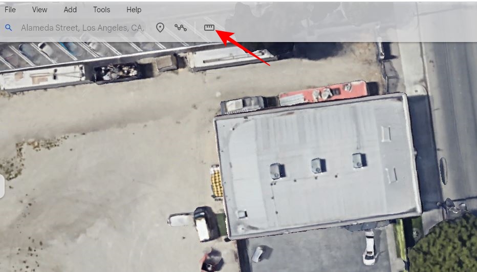
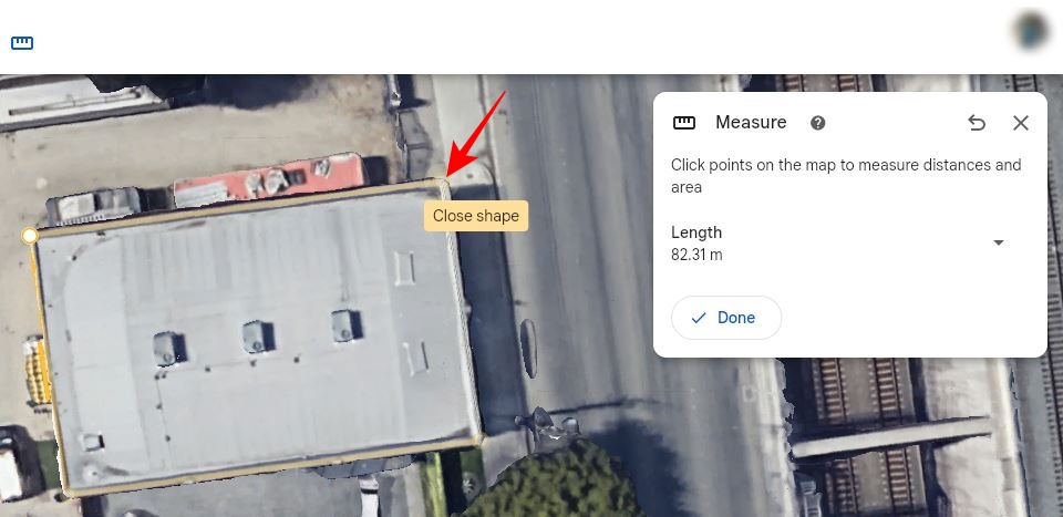
The area and perimeter of the roof will be displayed on the Measure popup. You can click Save to Project to save your measurements to Drive project or Local KML file.
2. Using Google Earth Pro for PC
While measuring a roof with Google Earth’s web version is more straightforward, the Pro version offers additional data import and export features. It is also suitable for more accurate measurements due to its better GIS data filtering capabilities. You can download and install the Pro version from the Earth Versions page on the Google Earth website.
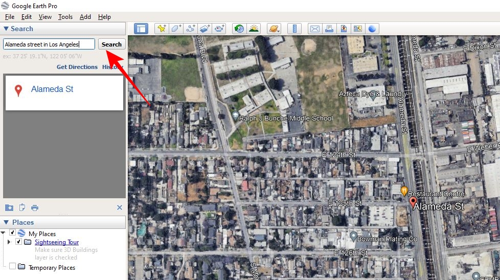
- Launch Google Earth Pro.
- Type a location in the Search bar at the top left and click Search.

- Double-tap on the map to zoom in and find the building roof you want to measure.
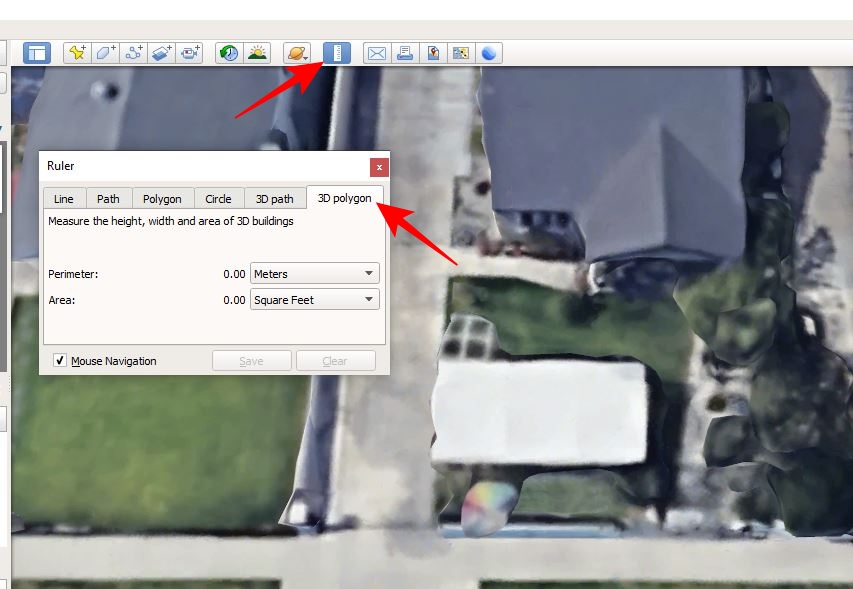
- Once you locate the building, select the ruler icon from the top menu.
- Go to 3D polygon in the Ruler popup.

- Click the measuring unit box alongside Perimeter and Area to select a suitable measuring unit.
- Check mark Mouse Navigation at the bottom left of the ruler popup.
- Move the cursor to the first corner of the roof and single click to mark it.
- Go to the next corner and click to mark it.
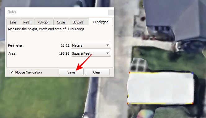
- Repeat the same for the remaining corners of the roof and join it back to the first corner to form a polygon.
- The area and perimeter of the roof will be displayed in the Ruler popup.
- You can click Save to go to Google Earth- New Polygon popup, where you can note your measurements.

- Click Ok to save it under Places.
How to Measure a Roof Using Google Earth on Android and iPhone
You can use the Google Earth app for Android or iPhone to measure a roof as well. The process is mostly the same as the web version.
- Launch Google Earth.
- Tap the search icon at the top left.

- Type the building’s location in the search bar and run a search.
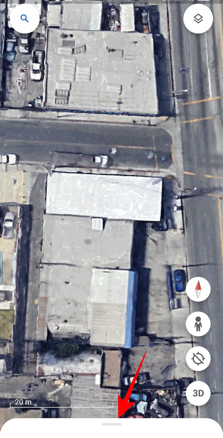
- Once you find your building’s location, zoom in on the roof you want to measure.
- Go to the white bar at the bottom; press and drag it upwards.

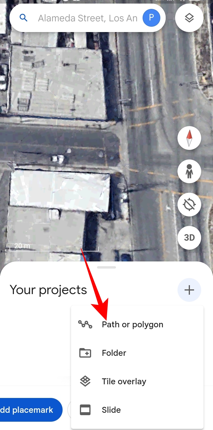
- Tap More under Your Projects.
- Select Path or Polygon from the popup options.

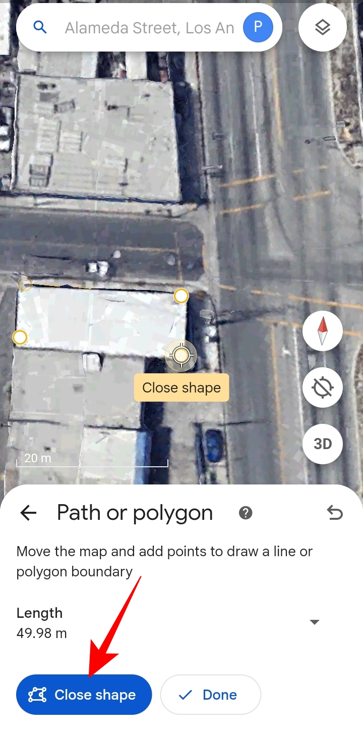
- Move the map to select the first endpoint of the roof and tap Add point.
- If you selected the wrong point, you can remove it by tapping the undo icon alongside Measure.
- Move the map again to select the next point and tap Add point again.
- Repeat it for the remaining endpoints and tap Close shape.
The perimeter and area of the roof will be displayed under Path or Polygon. Like you save a Google Maps route, you can save roof measurements to Google Earth by tapping Save to project.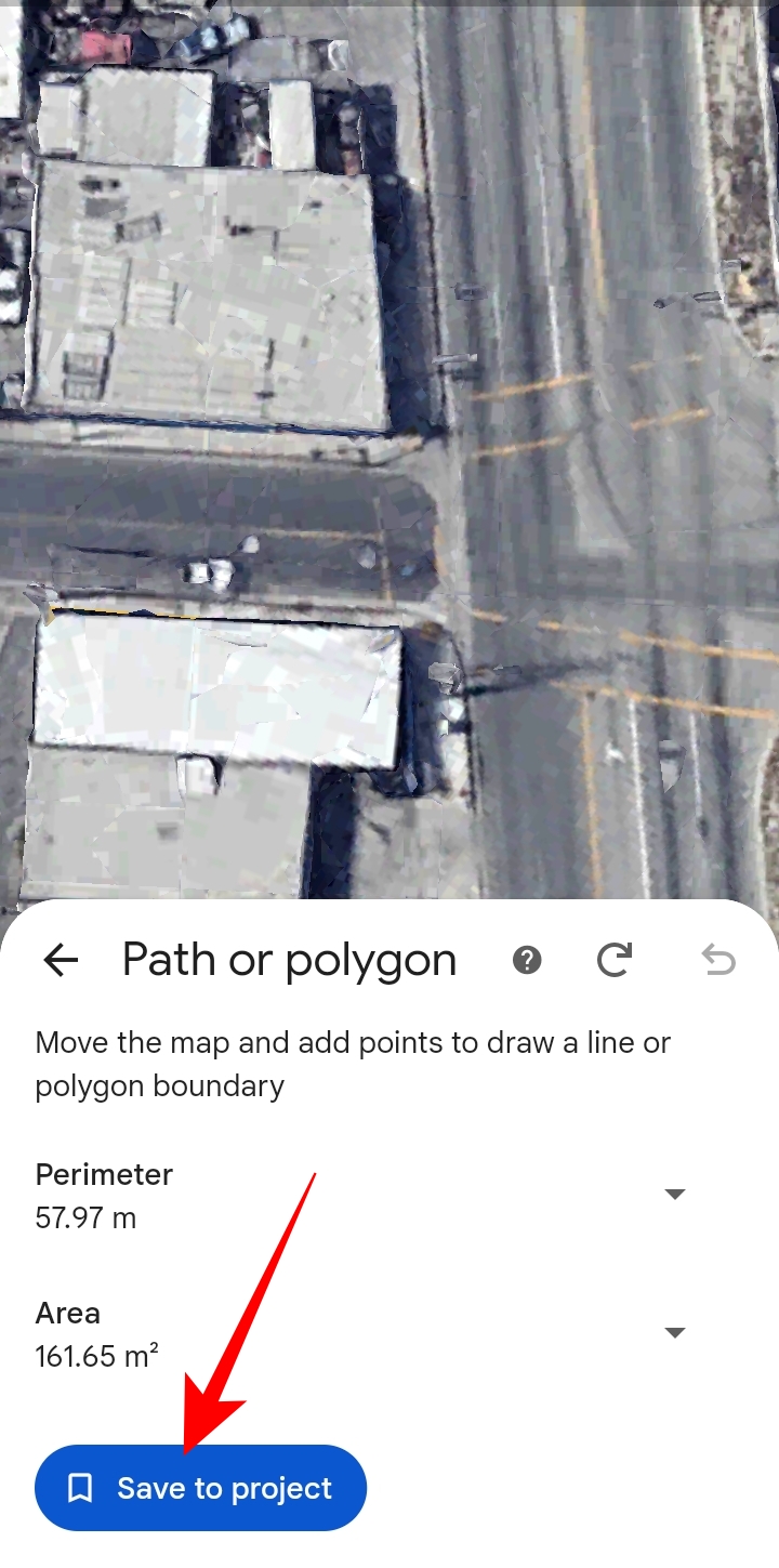
Once saved, you can access the roof measurements under Your Projects’ Drive project or Local KML file section on the app, depending on where you save it.
Google Earth to Measure Roofs for Free
Google Earth is a powerful tool to explore locations and measure the area of any space, all for free. Better still, you can go with its Pro version, which has advanced capabilities for professional purposes such as performing land surveying, taking construction measurements, batch geocoding, etc.
Now that you know how to use Google Earth to measure roofs, learn how to use Google Maps to measure distances.
FAQs
A. Google Earth allows you to measure the distance between two points and the area of any shape, be it a polygon or a circle. To measure a yard with Google Earth Pro App, you can go to Ruler > Polygon. After you select a polygon, you can use the mouse to mark and join your yard’s endpoints to form a shape. Once you close a shape, the area and perimeter of your yard will be displayed on the Ruler popup.
A. There are various roof measuring tools on the web. However, the most accurate roof measuring tools are not free. Google Earth is the best tool among all the free options. If you want a free Google Earth alternative to measure roofs, you can also use ERoofPro.